
Crete has nearly 100 smaller islands surrounding it and many of these can be visited with regular boat trips or with a private hire. Some of the islands are protected national parks (called Kri-kri) though and can’t or shouldn’t be visited. Many of the lesser known islets are also hard to identify with even google maps not showing names. Whilst we may have some separate pages for the most popular islands to visit, here we summarise details for all the islands for those people who like to explore a bit further from the beaten track
Islands with regular boat trips available
Spinalonga & Mirabello Bay
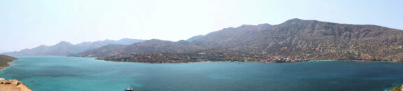 Mirabello bay is a large bay on the north coast of Crete towards the eastern end of the island near Agios Nikolaos. Spinalonga (or Kalydon as it is also known) is probably the best known island anywhere around Crete. It is famous as a former leper colony and is featured in the book ‘The Island’ by Victoria Hislop. Before being a leper colony the island was the site of a Venetian fortress and has been populated on-and-off for nearly 2 millennia. Spinalonga is a museum preserved by the Greek state and costs €8 to enter (still a good price, but a notable increase from the €2 it cost until recently). Boat trips to Spinalonga run regularly from Agios Nikolaos (€16–25, 1 hour journey) and Elounda (€12 return, 30–40min journey) as well as from the nearby village of Plaka (€8 return, 5 minute journey). Trips from Agios Nikolaos and Elounda often include additional stop offs for swimming and can include guides or lunch, whilst travelling from Plaka offers the opportunity for lunch on the seafront in Plaka at once of the tavernas there. Most visitors spend around 90 minutes on Spinalonga but if you want to be more flexible the best option is the boat from Plaka as this runs back and forth every 30 minutes and your ticket is an open return. Whilst it is a little bit of a climb it is worth following a path to the top of Spinalonga as the views are superb.
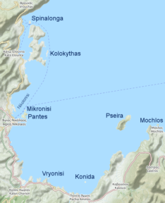 Agios Pantes, Mikoronisi & Nikolonisi are small islets just off the coast of Agios Nikolaos. Some boat trips to Spinalonga may stop by these to allow swimming. It would also be possible for a strong swimmer to swim to them as they are less than 1km from the coast, but care must be taken of boats and water sports. Kolokytha is a small island just behind the Kalydon peninsula. Many boat trips to Spinalonga from Agios Nikolaos stop here as it has an unspoiled sandy beach. Pseira is an island on the eastern side of Mirabello bay that has archaeological remains from Minoan and Mycenean civilisations. There are no regular boat trips but a private hire could be arranged and experienced kayakers may choose to visit. Winds and currents can be strong in the 2 mile crossing so it is not advisable to swim or for inexperienced sailors or kayakers to attempt the journey. Konida is a small islet of little note in the south of Mirabello bay just off the coast from Pachia Ammos. Mochlos is a small island only 150m off the coast from the current village of Mochlos. It is thought that in Minoan times it was connected to the mainland (sea levels were lower in Minoan times), and there are ruins from a Minoan settlement by the present-day village. Google Maps calls Mochlos ‘Nisida Agios Nikolaos’. Mochlos is also a short drive from Richtis Gorge making it easy to visit both in the same day.
Chrissi
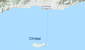 Chrissi island is actually 2 islands — the main Chrissi island itself and Mikronissi just to the east. Also known as Gaidouronisi (Donkey Island) Chrissi is another popular island with daily boat trips from the harbour in Ierapetra which leave around 9.30 — 10am and return around 5–6pm, taking about an hour each way. The regular boat service runs from mid May until late October. The name Chrissi means ‘golden’ and it lives up to it’s name with fine golden sand that helps it look like a stereotypical ‘tropical paradise’. There isn’t very much shade on the island so if you go in the summer months it is important to take something to provide shade and also take good quality suncream. The ferries drop off on one coast and pick up on the other coast so make sure you know where to go to catch the ride home. It is also possible to camp on Chrissi and some people do this. Most people who visit Chrissi do so for the clean water, beautiful sand, and warm shallow bays perfect for snorkelling, but there are also some Minoan ruins on Chrissi which can be viewed.
Gavdos & the Gulf of Mesara
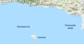 Gavdos is another reasonably well known island off the south west coast of Crete which can be reached by boat from Paleochora or Chora Sfakion. There is a regular schedule throughtout the year as Gavdos has a small permanent population. Gavdos is only 170 miles from Libya and is in fact the southernmost land in Europe. Due to it’s size and history Gavdos is worthy of a full article of its own so we wont repeat that here. Gavdopoula is a small island to the north-west of Gavdos which is a protected nature reserve for migratory birds and sea life. Much nearer to the coast of Crete are 2 small islets collectively known as the Paximadia islets. These are individually named Paximadia Ena (one) and Paximadia Dio (two). Locals sometimes refer to them as Elephant. In the peak months the Paximadia islands can be visited by boat from Kokkinos Pirgos and Agia Galini. The website Cretan Beaches has good information about the beaches on both.
Gramvousa & Kissamos Bay
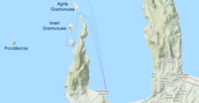 There are 3 small islands just off the north-west coast of Crete, near to Balos Lagoon. Imeri Gramvousa has the remains of a Venetian fort and thanks to it’s history as part of Cretan independence from the Ottoman empire it is a popular destination. It is included on most boat trips to Balos Lagoon. Just to the north is Agria Gramvousa which is less visited. Pondikonisi (known to locals as mouse island) is further to the west and is also uninhabited and rarely visited. Next to it is a small islet called Pontikaki, which means small mouse.
Dia & the Gulf of Heraklion
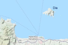 Dia is a large island immediately north of Heraklion that features in much Greek mythology and is now a protected nature reserve. There are sailings from the ports in Gouves, Hersonissos and Heraklion but not as frequently as to some of the other islands. It is possible to arrange to stay overnight on Dia but this must be arranged with the Heraklion port authority. Dia served as the principal port for many civilisations in Crete from Minoan times and offers some interest for historians. Dia is not particularly renowned for beaches but there are places to swim for those wishing to do so. There are also 2 small islets by Dia: Paximadi এবং Petalidi which are uninhabited and rarely visited.
Other notable islands and islets
Agioi Theodoroi & Chanion Bay
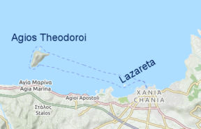 Agioi Theodoroi are 2 islets just off the coast to the west of Chania. There are 2 islands: Agios Theodoros and Mikros Agios Theodoros. Agios Theodoros, also known as Thodorou is the larger island and is home to native Greek Ibex called Kri-Kri. There are the remains of 2 Venetian fortresses, the higher one being called Turluru, which is a name sometimes used for the island. The smaller islet of Mikros Agios Theodoros is also known as Glaraki (Gull) and Theodoropoula. As the islands are an important nature reserve for Kri-Kri visiting is not permitted except during the ones-a-year festival the feast of Saint Theodore. Much nearer to Chania is the islet of Lazareta which has a small but nice beach which is visited by some boat trips and is popular with snorkellers.
Souda bay
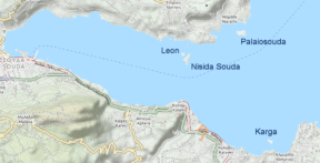 There are a number of small islands in Souda Bay near Chania. Nisida Souda (also sometimes called just Souda features in Greek mytholody and is also home to a Venetian fortress. There are limited numbers of boats that run trips to Souda in peak season from various places on the north coast from Chania to Rethymnon, but only guided-tours are available. Leon is next to Souda island and is rarely visited. Palaiosouda, also known as Marathi is popular for snorkelling and scuba diving. Private boat trips can be booked in Chania. Karga is on the south side of Souda bay near to Almirida. It is similar to Palaiosouda in that it doesn’t have much in the way of beaches so is mainly popular with divers.
Bay of Malia
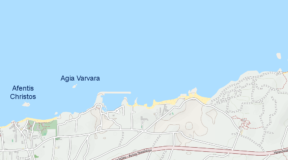 There are 3 tiny islands in the Bay of Malia. Afentis Christos is directly in front of the main Malia tourist beach and can (and is) easily swum to. It has a small church on it. We advise visitors to not climb on the church or to ring the bell as this is disrepsectful and is likely to offend locals. To the east of Afentis Christos is Agia Varvara which is rocky and of little note. Further still to the east, near Sissi, is another small rocky outcrop which is not identified on maps.
The Dionysades & Cape Sidero
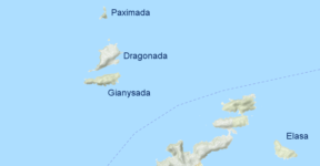 The Dionysades are a group of 4 islands off the north-east peninsula in Crete which are part of an environmentally protected area. Dragonada is the largest island. Gianysada is the southernmost island of the group. Paximada এবং Paximadaki are home to Eleonora’s Falcon which migrates from Madagascar. It is not advised for regular tourists to visit these islands. Elasa is on the opposite side of the peninsula from the Dionysades, further south and east. It is part of the same protected area and also should be left to nature.
The Grandes & Kouremenos Bay
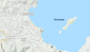 The Grandes islands are less than 1km off the coast at Palaiokastro in Kouremenos Bay. The middle islet is Prasonisi which has a bit of beach. The other 2 islets, Savoura to the south, এবং Paximadi to the north are little more than rocks. There are a number of shipwrecks in the area so it is a good place to visit for divers. Kouremenos Bay is popular with wind surfers which gives an idea of the levels of wind in this part of the Crete. It would be possible to swim to the Grandes islands but care should be taken if the winds are strong as this can lead to strong currents. The beach at Chiona (or Hiona) on the mainland is a better beach than anything on the islands as can be seen in the video below.
Sarantos Nikos has filmed a video of the Grandes with a drone which gives you an idea of the clarity of water and the small size of the islands. Also visible in the video are parts of the mainland and the nearby island of Elasa.
Kavali & Kymo
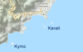 Kavali is a group of 3 small islets just off the coast at Xerokambos. The largest island is Kavallos which is the southernmost. Kefali is just north of Kavallas, এবং Anavatis (also called Kavaloi) is a little further to the east. Like the Grandes to the north all 3 islands lack a beach, and nesting spots for several species of bird including falcons and vultures. The nearby Alatsolimni beach on the mainland is a nice sandy beach. The mainland nearby also has a saltlake in spring that attracts many migrating birds which may be of interest to ornithologists. Kymo (aka Koumeli) is a small islet a little to the south of the Kavali group. It also has no beach and has nothing of note to see.
Koufonissi and Cape Goudero
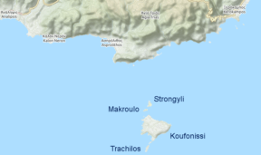 Koufonissi is a fairly large island to the south of east Crete. There are sometimes regular boat trips to Koufonissi from Makrys Gialos in peak season but this hasn’t been the case every year so check before travelling. An alternative would be a private hire which would likely cost around €50–60 per person. Koufonissi does have lovely sandy beaches, and some interesting Minoan and Roman era ruins, as well as a more modern church — the church of Saint Nikolaos, and a lighthouse that was destroyed in the second world war. There are 4 other much smaller islets around Koufonissi: Makroulo, Strogilo, Trachila এবং Marmara none of which are particularly noteworthy.
Psili Ammos bay
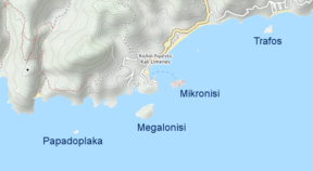 Trafos is only 100m off the mainland and can easily be swum to. There are the remains of the ancient town of Lassea on the mainland. Mikronisi (also known as Aghios Pavlos or St. Paul’s Island) is to the west of Trafos and is occupied by an oil storage terminal so is not a place for tourists. The next island in the group is Megalonisi which is just west of Mikronisi. Megalonisi has a lighthouse but is otherwise of little note. Papadoplaka is the smallest and most westward of the islets. It is the top of a reef that protrudes from the water and has no beach.
Phalasarna bay
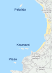 Phalasarna is a well-know beach on the west coast which forms a natural bay. It has 3 tiny islets that can be swum to. Koursaroi is the towards the south of the bay and is the largest. It is actually a group of rocks rather than a single island and it has one tiny area of sand. It is less than 100m from the mainland beach. Petalida is the furthest north of the 3 and is around 400m from the nearest point of the mainland or about 1km from the main beach. It is rocky and has no beach. Prasonisi is the furthest south, approx 500–600m from the coast, and has a small bit of sand on the eastern side
Larger islands with ferry service from Crete
Antikythera
Antikythera is a large inhabited island to the north west of Crete famed for the ancient technology named after it. Boats sail regularly from Chania
Santorini
The famous (and still active) volcano of Santorini is due north of Crete and boats sail daily year round from Heraklion. Higher speed catamarans make the journey from May to October but out of season only the much slower ferries provide a service. A round trip is typically €100–150 per person in peak season although it can be done for less if you watch for discounted prices. Santorini is much bigger than most people realise as it is not a single volcanic crater but an island formed from a series of eruptions over 200,000 years. To drive from the port to the most popular northern village of Oia takes around 35 minutes, whilst walking would is a trip of 18km including a climb of around 500m.
Other islands
Ferries from Heraklion also link to many other Greek islands in the Aegean including…
- The Cyclades: Anafi, Andros, Ios, Milos, Mykonos, Naxos, Paros, and Tinos
- The Dodecanese: Chalki, Karpathos, Kasos, and Rhodes
A complete list
For a complete list of all 93 islands, islets, and tiny rocks poking out of the sea around Crete Wikipedia has a template table with a full summary. As far as I am aware this includes every bit of rock no matter how notable. Cretan Beaches also has quite detailed information about many of the more notable islands and groups of islets although their list is not as complete as the one on Wikipedia.
উত্তর দিন